SkyDemon is a flight planning and navigation software developed by Divelements from United Kingdom, mainly suitable for providing pilots with required data during aviation flight. It provides detailed aeronautical data and charts to ensure pilots have all the information they need for any flight, keeping the aeronautical process safe.
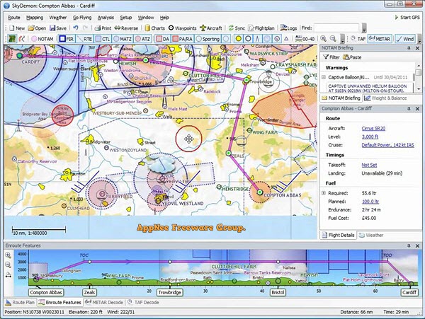
SkyDemon's flight planning feature is designed to make flight planning less tedious by delivering the best aviation summary information directly to your fingertips in real-time as you explore charts and try out potential journeys. Its real-time briefing data mainly includes NOTAM, airport documents and maps, TAF, METAR and wind direction aloft. It can help you plan your trip, brief you on potential hazards, prepare you to fly and analyze track records. At the same time, SkyDemon will give you the confidence to fly further and more interesting places.
SkyDemon's navigation feature is designed to keep you safe and well-informed during your flight. You'll spend less time worrying about navigating and more time looking out the window and enjoying this experience. During the flight, SkyDemon will effortlessly guide you between waypoints and notify you of potential hazards. At target airports, you can use geo-referenced tiles for reference, use detailed local maps as a guide for approaches, or simply use them to get around an unfamiliar taxiway.
In short, SkyDemon is a very practical program that many pilots around the world use to plan their flights. It makes this process not so tedious and more interesting, you will have fun from the convenience and be glad that you got to know this application. It offers a lot of aeronautical information, all of which will be available with one click. Plus, you will get a host of features that will help you feel confident to fly further and explore more places of interest.
Key Features
| Flight Planning |
- SkyDemon vector charts are the clearest aeronautical charts you'll ever use, with dynamic airspace clipping and choice of map layers
- Route planning is as simple as touching consecutive waypoints and dragging to make changes
- Virtual Radar shows how your route relates to airspace, terrain, obstructions and other features
- Pilot Log facility calculates headings and groundspeeds from actual wind data, and shows useful frequencies
- Plates and other documents for relevant airfields are displayed automatically as you plan, and many are available georeferenced for use in flight
- Intuitive pan, pinch and rotate support with no loss of map clarity or text legibility
- File a VFR flightplan for your route directly to air traffic controllers
- Automatic TAF, METAR and SIGMET briefing as you plan a route, with graphical decoding
- Rainfall data can be overlaid on the main map, with animation, showing the trend of rainfall over time
- Integration of GAFOR route forecasts for Switzerland, Austria, Slovenia and Croatia
- Both narrow-route and area NOTAM briefings available, updated as you plan
- Advanced NOTAM graphical interpretation and depiction on the main map
- Easily print your PLOG and the output from various briefings
- Warnings for airspace and other potential hazards to your flight, updated in real time
- Airfield Admin Information shows useful contacts and other details for airfields featured in our charts
- Forecast winds aloft are automatically retrieved for the flight time and displayed on the map
- Create an advanced flight performance profile for each aircraft you use
- ATS Routes mode offers an alternative chart presentation for flight along airways
- Accurate fuel, weight and balance calculations including flight costings
- Create an unlimited number of user-defined waypoints
- Analyse your track logs for posterity
- Choose between six different vector chart styles
- Extensive European chart coverage as standard
|
| GPS Navigation |
- Intelligent warnings for approaching airspace, NOTAM, obstacles, terrain and other hazards
- Virtual Radar shows a side-on projection of all approaching features and how your trajectory relates to them
- Vector map automatically follows the aircraft in north up, track up or course up orientation
- Clear and concise instruments show you flight statistics and help keep you on track
- An HSI/ILS instrument helps you keep to your planned route and line up early for approach
- Live Pilot Log shows progress through your route, ETAs, ATAs and useful frequencies based on your current position
- TerrainSafe dynamically colours mountainous terrain around you to quickly identify safer areas
- Direct To allows easy re-routing in a hurry by picking from a selection of nearby airfields
- Approach Information shows runway diagrams, TAF, METAR, NOTAM and other airfield details useful for making an approach
- Live updates of TAF and METAR while in flight, with associated alerts*
- Extended runway centrelines appear automatically on the map as you near your destination airfield
- Permanent display of position relative to nearest well-known waypoint, for position reporting
- Easy changing of the planned route while in flight by touching and dragging
|
Fan Made Demo Video
System Requirements
- Internet connection required for live weather update while in flight.
- Microsoft Edge WebView2 Runtime
Edition Statement
AppNee provides the SkyDemon Edition multilingual full installers and universal keygen for Windows 32-bit & 64-bit.
Installation Notes
for v3.15.x+:
- Register a Personal Trial account on official site (free trials of SkyDemon may be not available currently)
- Download and install SkyDemon from official site
- Login with your trial account info (to generate the trial license file)
- Run keygen, click 'Get From Trial File', open the trial license file, and click 'Generate' to generate a Full license file
- Done
Related Links
Download URLs
| Version |
Download |
Size |
| for Windows |
| Latest |
 |
n/a |
| Universal Keygen |
| v3.15.x+ |
 |
61.1 KB |
(Homepage)