Pix4Dmapper (formerly called Pix4UAV) is a is a fully automatic, fast and professional UAV mapping and photogrammetry software developed by Pix4D from Switzerland. It is the research result of EPFL (École Polytechnique Fédérale de Lausanne), a world-class research institution, in the past 10 years. It is also the unique UAV data and aerial image processing software integrating full-automatic operation, fast processing and professional precision in one place in the market.
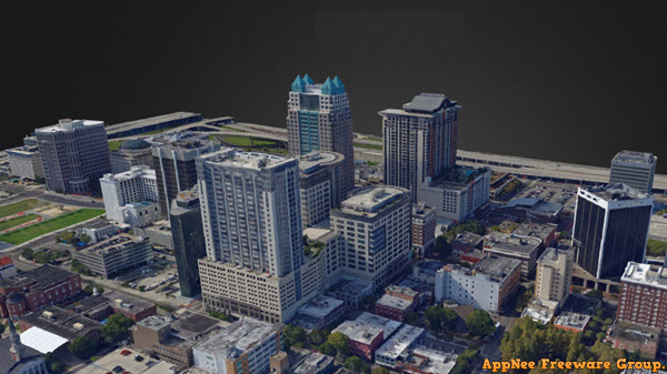
As a UAV 3D modeling software, Pix4Dmapper uses a UAV to collect data, and achieves automatic 3D modeling via aerial photography and measurement. It has a sophisticated workflow, can quickly realize cloud computing, and generate the most accurate reports, etc. It supports the simultaneous processing of up to 10,000 images, allows to process data from different cameras in the same project, and is able to output the original aerial images as DOM and DEM data format that can be read by any professional GIS software. In addition, it can automatically extract frames from video to create projects, and comes with the automatic orthophoto function.
Without the need of professional knowledge and manual intervention, Pix4Dmapper can quickly generate professional and accurate 2D maps and 3D models from thousands of images. Therefore, it has been widely used in all walks of life, and has achieved the best aerial surveillance and data analysis, including: aviation mapping, disaster emergency, safety law enforcement, agriculture and forestry monitoring, water conservancy, flood control, power line inspection, marine environment, university research, and so on.
Key Features
| Function | Features |
| INPUTS |
|
| PROCESSING |
|
| RAYCLOUD EDITOR |
|
| VOLUME MANAGER |
|
| MOSAIC EDITOR |
|
| INDEX CALCULATOR |
|
| OUTPUT RESULTS |
|
| COLLABORATION | Web share, inspection and visualization |
| MULTI-LINGUAL | Language Options |
Official Demo Video
Supported Outputs
| Type | Formats |
| Colored point cloud | .las, .laz, .ply, .xyz |
| Classified point cloud | .las, .laz |
| Orthomosaic | GeoTiff (.tif), .kml |
| Digital surface model (DSM) | GeoTiff (.tif), .xyz, .las, .laz |
| Digital terrain model (DTM), Digital elevation model (DEM) | GeoTiff (.tif) |
| 3D textured mesh | .ply, .fbx, .dxf, .obj, .pdf Level-of-detail mesh in .osgb, .slpk |
| Contour lines | .shp, .dxf, .pdf |
| Facade digital surface model | GeoTiff (.tif) |
| Facade orthomosaic | GeoTiff (.tif) |
| Reflectance maps | GeoTiff (.tif), .shp |
| Index maps | GeoTiff (.tif), .shp |
| Thermal maps | GeoTiff (.tif) |
Edition Statement
AppNee provides the Pix4Dmapper Pro/Enterprise Edition multilingual full setup, local keygen for Windows 32-bit & 64-bit, as well as full installer and unlocked file for Mac.Installation Notes
for v4.4.12 on Windows:- Uninstall all previous versions of Pix4Dmapper very cleanly (using tools like Total Unisntall), including all files, folders and registry keys
- Install 'Pix4Dmapper_4.4.12.msi'
- Run patch 'HWID.exe'
- Find your PC/device name from "Control Panel\All Control Panel Items\System\", type it to the "Enter Owner value" field in patch, click 'Generate HWID', and copy the generated HWID
- Run '4D-Permit-4X.exe', paste the HWID, and click 'Decode'
- Change the "Days" value from 1 to 9999, and click 'Save REG'
- Double click the generated reg key file to import license info
- Copy the unlocked file 'version.dll' to installation folder (it's used to block Pix4Dmapper from connecting to the Internet); Or, you can also use the 'Pix4DTool.exe' instead (***)
- Then you may need to sigh out/log off/restart to make the registry change take effect
- Done
- ipconfig /flushdns (Free DNS Cache)
- ipconfig /registerdns (DNS Registering)
- ipconfig /release (IP Release)
- ipconfig /renew (IP Renewing)
- netsh winsock reset (DNS Socket Reset)
- Make sure you don't have any Pix4Dmapper installed on your computer
- Add the following line to your hosts file:
- 127.0.0.1 mapper.pix4d.com
- Download and install Pix4Dmapper, do not launch program
- Run the local keygen as administrator
- Input any different name you like (numbers + letters only; not more than 12 characters; and no spacebar, dot,...), and click the button
- Done
Related Links
Download URLs
| License | Version | Download | Size |
| for Windows | |||
| Pro Edition | v2.0.104 |  |
164 MB |
| Enterprise Edition | v4.5.6 | |
416 MB |
| for Mac | |||
| Pro Edition | v2.0.104 |  |
175 MB |