Global Mapper is a pretty professional map plotting software with comprehensive and powerful functions, as well as friendly UI for everyone to use (praised by numerous users around the world). Global Mapper by itself has all the features of a GIS, and can simplify the complex problems. In the same industry, its main rivals include Esri, GeoMedia, Manifold, and MapInfo GIS products.
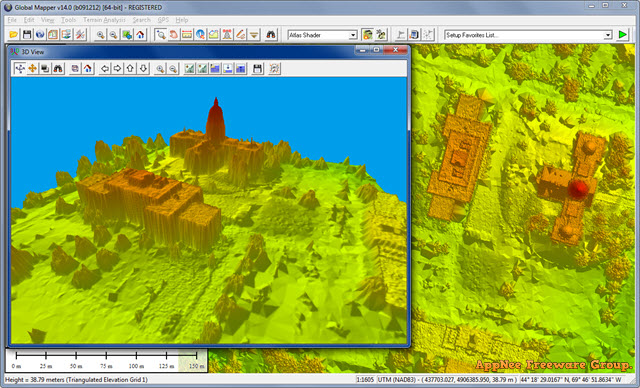
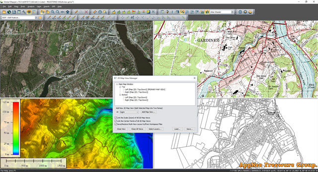
In terms of basic map plotting, Global Mapper is able to plot the data (such like SRTM data) as raster map, elevation map, and vector map; view, edit, convert, print all kinds of map graphics files; track and log GPS data; utilize the GIS (Geographic Information System) information resources; support batch download and import for Google Maps data; direct access to the USGS (United States Geological Survey) satellite photos, TerraServer database and Global Mapper internal topographic map; view the elevation data in a realistic 3D viewing angle, and so on.
In addition, the Global Mapper also provides distance and area computation, raster mixing, contrast ratio adjustment, altitude query, LOS (line of sight) computing, as well as some other advanced features. They can help users easily implement image correction, generate contour by surface data, survey the water-shed through surface data, convert 3D point data into triangular polygons and grids, efficiently complete the repetitive tasks via the built-in scripting language or numerous batch conversion options, and more.
All in all, Global Mapper has currently the most excellent image processing technology and the simple and straightforward functions design, and is able to help you achieve all the mapping features you need. As a result, you can, at the fastest speed, process the finished data products, make clear and precise maps, and apply them to all areas of our life.
Key Features
- Supports 250+ file formats
- Flexible View Interface
- Global Energy Mapper
- Feature Extension Plugin Support
- 3D Data
- Data Importing / Exporting
- Spatial Database Support
- LiDAR Point Clouds
- Access to free online data sources
- Google Earth Support
- Image Rectification
- Geocoding
- Graph and Chart Manager
- Drawing and digitizing tools
- 3D rendering and elevation tools
- Batch file conversion
- Support for scripting
- Terrain Analysis
- Advanced analysis tools
- Terrain modification tools
- Volume calculation tools
- Data Processing
- GPS Tracking
- GPS data management tools
- Geographic calculator integration
- Map Printing and Web Publishing
- Raster Calculator
- Available in both 32 and 64 bit
Official Demo Video
Edition Statement
AppNee provides the Global Mapper Pro Edition multilingual full installers and unlocked files, as well as portable full registered versions for Windows 32-bit and 64-bit.Installation Notes
for v23.1:- Download and install program
- Copy the unlocked file to installation folder and overwrite
- Done
Download URLs
| License | Version | Download | Size |
| Pro Edition | v18.2.0 | reserved | n/a |
| v19.0.0 | reserved | 141 MB | 154 MB | |
| v21.1.0 | reserved | 200 MB | 218 MB | |
| v23.1 | reserved | 347 MB | |
| v24.1 | reserved | 451 MB | |
| v25.1.1 | 64-bit | 459 MB | |
| v26.1.0 | 64-bit | 532 MB |